
Before the Park
The Park’s founding sits within a much longer history of Manhattan as a Native homeland and, later, a Dutch and British colonial city. The Smithsonian’s Native Knowledge 360° resource offers Native perspectives on the island’s seventeenth-century land exchanges. The nineteenth-century deeds tell the story of the Park’s legal creation, rather than the beginning of the land’s human history.
National Museum of the American Indian · Native New York
The name Gramercy is older than the garden. In his 1921 history, John B. Pine traces forms of “Crommessie” in seventeenth-century records. He connects the name to Dutch words for a crooked little knife, describing the turns of a brook. That is Pine's interpretation.
In 1761, James Duane acquired the farm and called it Gramercy Seat. The land combined higher ground with wet, low-lying areas. This was a very different landscape from the streets and buildings that now frame the Park.
December 17, 1831
A garden held in trust
Samuel B. and Mary R. Ruggles conveyed the land for Gramercy Park to five trustees on December 17, 1831. The indenture described an ornamental garden, an iron enclosure, walks, trees and continuing care. It linked the use of the garden to the surrounding residential lots.
The importance of the document is its long view. Creating a garden was only the beginning: the deed also set out a structure for maintaining it after its founder was gone. The Park’s landscape and its enduring care were conceived together.
Reading the original plan
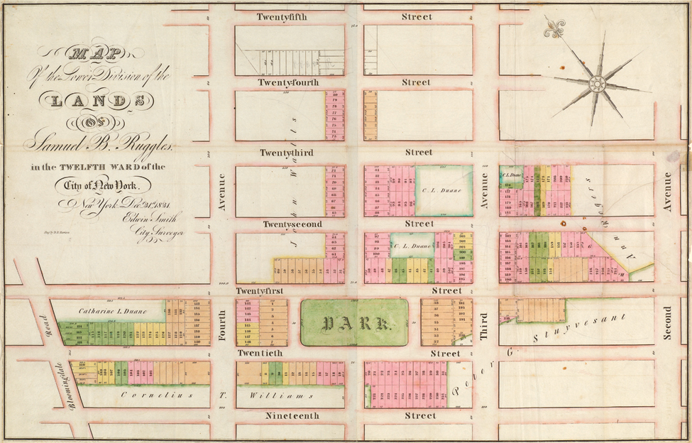
Begin with the open ground at the center of the plan, then follow the homes arranged around it. The garden would give those houses a setting; the surrounding properties would help sustain the garden. Streets connected this small square with the growing city beyond it.
Edwin Smith’s December 1, 1831 map, held at New York Historical, offers a companion to the deed. Pine’s account explains the allocation: forty-two lots for the garden and sixty-six surrounding lots, of which six were set aside for streets. The plan made room for both a protected center and routes through the neighborhood.
The founding indenture · PDF · Explore the historical maps · 1831 map · Archive catalogue
The December 31, 1831 plan reproduced at the opening of this chapter shows the Park among the surrounding streets and numbered building lots. Edwin Smith drew the map and D. R. Harrison engraved it. This copy comes from the Samuel B. Ruggles papers at The New York Public Library, reproduced by the National Park Service. It is distinct from the December 1 map catalogued at New York Historical.
A plan beyond the fence
Ruggles’s work extended beyond the garden. Lexington Avenue and Irving Place opened a north–south approach to the square, and he helped advance the development of nearby Union Square. He gave the new streets names connected with the American Revolution and the writer Washington Irving.
Pine recounts the extensive work needed to make the land buildable: higher ground was cut down and lower ground filled. The familiar relationship between open space and surrounding homes emerged from deliberate planning and substantial physical work.
1833
Confirming the arrangement
A further deed dated December 24, 1833 confirmed the right to use and enjoy the Park as an easement attached to the surrounding lots. Together, the early documents explain why Gramercy Park developed differently from a municipal park.
For today's access rules, see The Park Today.
Why this history uses 1831
The date of the founding conveyance is December 17, 1831. Both the acknowledgment in the deed reproduced here and Pine’s transcription support it. Dates such as 1832 sometimes repeated in later summaries should not displace the dated document. The December 24, 1833 confirmatory deed is a separate step.
The making of the garden took longer than its legal creation. Pine says the ground was fenced and graded by the first recorded Trustees’ meeting in 1844. Pine does not date each section of the fence.